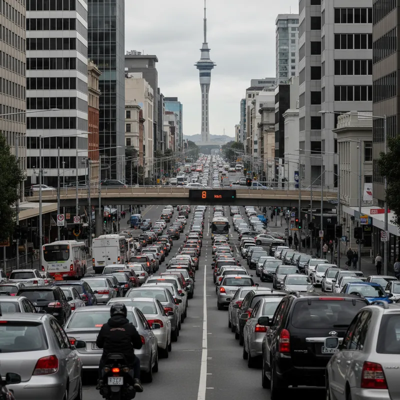
Auckland Transport has identified the 16 worst arterial choke points in the city. Data from the 2025 peak period in February reveals that some commuters are moving at the speed of a brisk walk during the morning rush hour. The worst congestion is concentrated in central suburbs that feed directly into the central business district. The slowest speeds were recorded in Newmarket and the inner city. At the intersection of Manukau Road and Broadway, traffic averaged just 8km/h during peak morning hours. The same speed was recorded for drivers on the Ponsonby Road and Newton Road corridor. In the North Shore, commuters on the Raleigh Road and Lake Road stretch fared only slightly better at 9km/h. For total time spent in a single stretch of gridlock, Ti Rakau Drive topped the list. Drivers traveling from Harris Road to Pakuranga Road faced a morning travel time of nearly 16 minutes for that section alone. Gillies Avenue followed closely with a 13.4-minute delay between Greenlane West and Khyber Pass Road. Although Auckland Transport faces pressure to improve flow, the agency described congestion as dynamic. Many factors including crashes, roadworks, and school holidays affect daily results.
Central suburbs feel the squeeze
The data shows that the bulk of morning traffic originates from suburbs immediately bordering the city centre. Grey Lynn, Mt Eden, and Remuera contribute significantly to the volume of vehicles entering the CBD. This concentration of traffic has made short commutes from inner-suburbs disproportionately slow compared to off-peak travel times. Local retail areas are also seeing the impact. While high foot traffic is usually welcomed, such as the Ponsonby Road café strip recording its best numbers in years, the local roads struggle to absorb the vehicle volume. Ponsonby Road remains one of the slowest routes in Auckland during the morning peak. Auckland Transport sources its speed and timing data from an external provider that tracks vehicles and mobile devices. This is the same method used by Google Maps to determine real-time traffic conditions. The high volume of data allows the agency to pinpoint specific intersections where infrastructure is failing to meet demand.
Growth and the charging debate
Transport experts attribute the worsening congestion to rapid population growth on Auckland’s outskirts. People living in the periphery must travel longer distances to access jobs and essential services in the central city. This has led to a 50 percent increase in traffic entering the CBD on Tuesday and Thursday mornings specifically. The government and Auckland Transport have discussed congestion charging as a possible solution to manage demand. However, geographic experts have cautioned that such a move could backfire. They warn that toll zones might push heavy traffic onto local residential streets as drivers seek to avoid fees. This would move the problem from arterial roads into quiet neighbourhoods. The pressure on the roading network comes as residents in areas like Arch Hill have already expressed concern over urban planning. Some residents have rallied against density changes, fearing that more housing without significant transport upgrades will only worsen the local gridlock. For now, the arterial roads remain the primary focus of the congestion data.
Western and northern delays
Congestion is not limited to the central core. In West Auckland, Lincoln Road and Triangle Road are major pain points. The stretch of Lincoln Road from Te Pai Place to Triangle Road is officially one of the city's 16 most congested areas. Similarly, Central Park Drive is struggling to cope with the morning influx of vehicles. On the North Shore, the Esmonde Road exit and the Upper Harbour Highway are frequently over capacity. The data identified the stretch from Parkway Drive to Caribbean Drive as a significant bottleneck. These areas serve as critical feeders for the motorway system, meaning a delay here often cascades across the entire northern network. Similar issues with infrastructure and demand are being mapped across the Tasman. In Western Australia, a new treasure hunt trail was designed specifically to help businesses handle foot traffic during major events, showing how cities are trying to move people without relying on cars. For Auckland, the immediate focus remains on whether the current arterial roads can be modified to improve flow. The identified 16 roads will likely form the basis for future transit priority projects. These could include more bus lanes or changes to signal timings at the most affected intersections. Auckland Transport will continue to monitor travel speeds as the city settles into its 2025 work and school routines.