Auckland’s cycling and walking network has received a major boost with two key projects officially opening in the past week, connecting communities and offering new sustainable transport and recreation options for residents.
A dawn karakia on Tuesday marked the official completion of long-awaited transport improvements on Great North Road. The project includes protected bike lanes along the ridgeline, which have been in use since late last year and are already proving popular with families and commuters.
Meanwhile, last Friday saw the public opening of the first section of the Te Whau Pathway, a scenic boardwalk path along the Whau River in West Auckland. The pathway has been a decade in the making and represents a significant new asset for the area, connecting the Northwestern Cycleway to Horowai Reserve in Te Atatū South.
Great North Road gets a glow-up
The completion of the Great North Road cycleway is a milestone for Auckland’s inner west, creating a safer route through Grey Lynn and improving access to surrounding suburbs. The separated bike lanes have transformed the busy arterial road into a more inviting corridor for people of all ages.
Since the lanes were unofficially opened late last year, they have been adopted by a wide range of users, from parents cycling with children to commuters on cargo bikes. The project, which at times seemed fraught with delays, provides a crucial link in the city's growing cycle network, making it safer to travel through the popular city-fringe suburbs.
The upgrades aim to make cycling and walking a more viable option for everyday trips, connecting residents to local shops, schools, and parks. With this section now complete, attention has turned to addressing other missing links in the inner west, such as the gap through the Grey Lynn shops, to create a truly continuous and safe route.
A vision for the Whau River
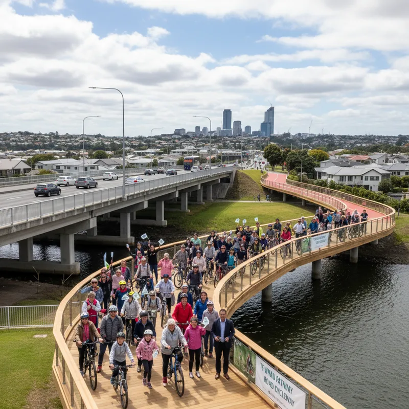
In West Auckland, the opening of a 1.3-kilometre section of the Te Whau Pathway was celebrated by more than a hundred people from the local community. The project, a partnership between Auckland Council and the Te Whau Pathway Environment Trust, has been in planning since 2014.
The new boardwalk stage of the Te Whau Pathway is a major piece of infrastructure ready for Aucklanders to walk or cycle on, doubling as a new sustainable transport route or place to exercise. The pathway will particularly benefit the West Auckland community, and is a vital connection between the northwestern cycleway and Horowai Reserve. {"type":"in_body_image","url":"https://ffqbmbvywrypmfjybtyu.supabase.co/storage/v1/object/public/article-images/auckland-opens-two-major-new-cycling-walking-paths-2.webp","alt":"New cycling and walking paths in Auckland with natural lighting and a realistic setting.","caption":"Auckland's new Great North Road cycleway and Te Whau Pathway boardwalk are now open."}
The combination of a four-metre-wide boardwalk and three-metre-wide concrete paths gives people a new perspective on the Whau River environment, with pop-out observation decks for enjoying the view. The path provides a safe and scenic connection to the Northwestern Cycleway for many Te Atatū South residents, a welcome alternative to the busy Te Atatū Road.
The ultimate vision for the Te Whau Pathway is to create a 15-kilometre route from Te Atatū to Green Bay, linking the Waitematā and Manukau harbours. Although the full project is still some years away from completion, this first major section is a significant step forward.
Project savings fund further expansion
In a rare piece of good news for a major infrastructure project, the initial stage of the Te Whau Pathway was delivered ahead of schedule and significantly under budget. The savings have been repurposed to fund the very next stage of the path.
The government confirmed last September that savings from the initial section would fund a further 400-metre stretch, which will include a new bridge linking Ken Maunder Park and Rizal Reserve in Avondale. Construction on this newly funded section is set to begin in April and is expected to be completed by November this year.
The successful design and construction of the boardwalk have raised questions about where this model could be applied next. Experts have suggested that the nearby Henderson Creek could be a prime candidate for a similar waterside path, which could link the suburbs of Massey, Royal Heights, and West Harbour to the Northwestern Cycleway and the future busway station at Lincoln Road.
Focus turns to missing links
While the opening of these two flagship projects is being celebrated, attention is also shifting to the smaller, but equally important, gaps in the existing network. Auckland Transport has recently installed protected cycle lanes on Surrey Crescent around Grey Lynn School as part of a road renewal project, a cost-effective method of expanding the network piece by piece.
However, significant gaps remain. Plans are still in development for Green Lane West, a critical east-west connection, as well as for safer routes on Cook Street and Wellesley Street East in the city centre. These projects aim to create a direct link for people walking and cycling from Queen Street to the Auckland Domain, and improve connections to other parts of the city centre.
Another key unfunded project is the planned connection from the eastern end of the Te Ara ki Uta ki Tai (Glen Innes to Tāmaki Drive) path to Panmure. This link would integrate the popular shared path with the new cycleways being built as part of the Eastern Busway project, creating a seamless active transport corridor through the eastern suburbs.